
The world of surveying has seen a major shift over the past few years. Thanks to advancements in drone technology, what once took days or even weeks can now be achieved in a fraction of the time. But does faster always mean better? Let’s break down how drone surveys stack up against traditional surveying — and which one makes the most sense for your project.
Introduction: Drone Surveys and Traditional Surveying
Surveying is the foundation of every successful project in construction, mining, real estate, and beyond. Traditionally, it meant boots on the ground, manual instruments, and a lot of time. Today, aerial survey inspections powered by drones are rewriting the playbook. But while drones offer exciting possibilities, traditional methods still hold their ground in certain scenarios.
How Traditional Surveying Works
Traditional surveying is a hands-on process. Skilled surveyors head out to the site, setting up equipment like theodolites, total stations, and GPS units to measure angles, distances, and elevations with precision. It’s a meticulous method that demands expertise, patience, and often a large team — especially for larger or more rugged terrains.
Despite being time-consuming, traditional surveying has built a solid reputation for accuracy over centuries.
How Drone Surveying Works
Enter drones — the game-changer. In drone surveying, unmanned aerial vehicles (UAVs) equipped with high-resolution cameras, LiDAR, or multispectral sensors fly over the site, capturing detailed images and data. This data is then processed into accurate maps, models, and reports.
Instead of spending days setting up and moving equipment around, a single drone flight can cover massive areas swiftly and safely, requiring just a small crew to operate.
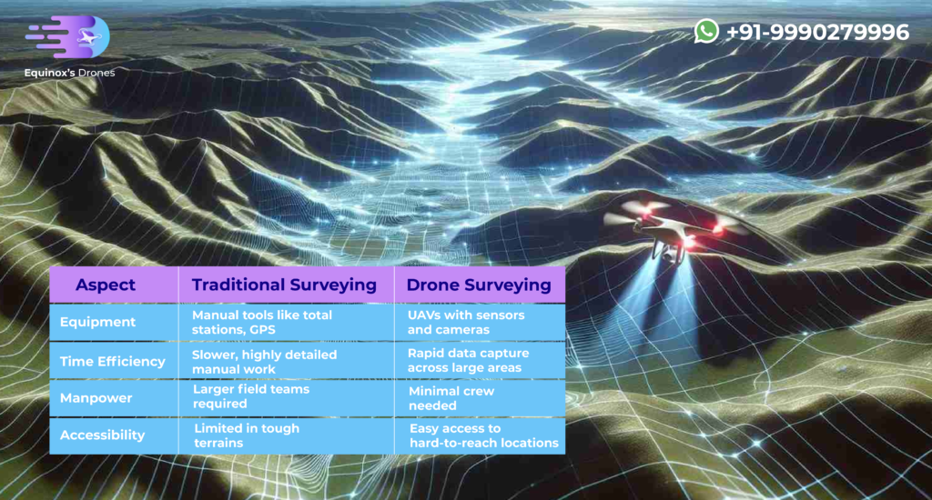
Key Differences Between Drone Surveys and Traditional Surveys
| Aspect | Traditional Surveying | Drone Surveying |
| Equipment | Manual tools like total stations, GPS | UAVs with sensors and cameras |
| Time Efficiency | Slower, highly detailed manual work | Rapid data capture across large areas |
| Manpower | Larger field teams required | Minimal crew needed |
| Accessibility | Limited in tough terrains | Easy access to hard-to-reach locations |
Both methods have their strengths — it’s really about what your project demands.
Data Accuracy: Drones vs. Traditional Surveying
If pinpoint precision is what you’re after, traditional surveying still leads the way, especially for legal boundaries or construction layouts. However, drone surveying isn’t far behind. When properly calibrated and combined with ground control points, drone surveys deliver accuracy that’s more than enough for most industries, including aerial survey inspections in mining, real estate, and infrastructure.

Speed: Drone Surveying vs Traditional Surveying
When it comes to speed, there’s no competition. Drones can survey hundreds of acres in a single day — what a traditional team might take a week to achieve. Faster data collection means faster decision-making, helping projects stay ahead of schedule and within budget.
Safety and Accessibility: Drone Surveying vs Traditional Surveying
Surveying challenging environments used to mean putting people in risky situations — think unstable cliffs, busy highways, or active construction sites. With drones, surveyors can collect the data they need from a safe distance. Whether it’s rough terrain or dangerous structures, drones make surveying safer and more accessible.

Cost: Drone Surveying vs Traditional Surveying
On the surface, drones might seem like an expensive investment. But factor in reduced labor, quicker turnaround times, and lower insurance risks, and drone surveying often ends up being the more cost-effective choice. Traditional methods, with their heavier manpower and longer timelines, can drive up costs, especially for larger sites.
Both drone surveying and traditional surveying have their place in today’s world. If your project demands millimeter-level precision, traditional methods are hard to beat. But for speed, safety, accessibility, and cost-efficiency, aerial survey inspections using drones are setting a new standard.
Choosing between the two comes down to understanding the unique needs of your project — and sometimes, the smartest approach is combining the best of both worlds.
FAQs on Drone Surveying vs Traditional Surveying
What is the main difference between drone surveying and traditional surveying?
Traditional surveying uses manual, ground-based methods, while drone surveying captures data from the air using UAVs.
Which type of surveying is most accurate?
Traditional surveying is slightly more accurate for ultra-fine details, but drone surveys offer impressive accuracy for most practical applications.
Is a drone survey worth it?
Absolutely — especially when you need fast, safe, and cost-effective site data for large or challenging areas.
What are the limitations of drone surveying?
Dense tree cover, bad weather, or projects needing legal boundary certification can be challenging for drones.
Can drones completely replace traditional surveying methods?
Not entirely. Drones are an incredible tool, but for legal documentation and certain highly detailed tasks, traditional methods still have the edge.