
Technology is changing the way we do many things, including how we survey land. One exciting advancement is the use of LiDAR (Light Detection and Ranging) mapping drones for precision aerial surveying. These drones, often referred to as UAVs (Unmanned Aerial Vehicles), have transformed the surveying industry by offering incredible accuracy and efficiency.
What is LiDAR?
LiDAR is a technology that uses light in the form of a laser to measure distances. It sends out thousands of light pulses every second and measures how long it takes for each pulse to bounce back from the ground. This data is then used to create a detailed 3D map of the area being surveyed. LiDAR technology can be mounted on UAVs, making them excellent tools for aerial mapping and surveying.
How LiDAR Mapping Drones Work
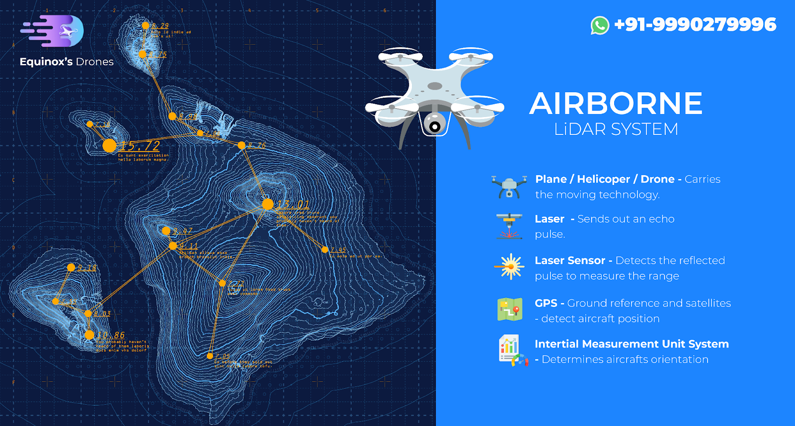
LiDAR mapping drones, also known as UAV mapping drones, are equipped with several high-tech components: a laser scanner, a GPS receiver, and an IMU (Inertial Measurement Unit). As the UAV drone flies over an area, the laser scanner sends out light pulses to the ground. These pulses reflect to the drone, and the time it takes for them to return is recorded. Using this information, the drone can calculate the distance to the ground and create a precise 3D map.
The GPS receiver and IMU help the drone know its exact position and orientation, ensuring the measurements are accurate. The data collected is processed using special software, turning it into detailed maps and models.
Benefits of Using Equinox’s LiDAR Mapping Drones
Unmatched Accuracy and Detail
LiDAR technology provides incredibly detailed and accurate maps. It can detect tiny changes in the terrain, making it perfect for tasks like land surveying, forestry management, and infrastructure planning.
Efficiency and Time Savings
Traditional surveying methods can be slow and require a lot of manual labor. UAV mapping drones can cover large areas quickly, significantly reducing the time needed for data collection. This means projects can be completed faster and at a lower cost.
Versatility in Different Environments
LiDAR mapping drones are versatile and can be used in many environments, from dense forests to busy urban areas. They can even see through vegetation to map the ground below, making them ideal for forestry and environmental monitoring.
Safety and Accessibility
Using UAVs for aerial surveying means surveyors don’t have to navigate dangerous or hard-to-reach areas. UAV inspection drones can safely survey steep slopes, dense forests, and construction sites without putting people at risk.
Cost-Effective Solution
Although the initial cost of LiDAR technology and UAVs might be high, the long-term benefits are significant. The efficiency and accuracy of UAV drone surveys lead to substantial cost savings compared to traditional methods.
Applications of LiDAR Mapping Drones
Land Surveying
UAVs are increasingly used for land surveying. They create detailed topographic maps and digital elevation models, essential for land development and construction planning. UAVs for surveying and mapping can identify subtle features and changes in the landscape that traditional methods might miss.
Forestry Management
In forestry, UAV aerial mapping drones help assess forest structure, biomass, and health. They capture detailed 3D data of the forest canopy and floor, allowing forestry managers to monitor tree growth, estimate timber volume, and detect vegetation changes.
Infrastructure Planning and Maintenance
LiDAR mapping drones are vital for infrastructure planning and maintenance. They survey roads, bridges, railways, and utilities, providing accurate data for design and maintenance. UAV inspection can detect structural deformations, erosion, and other issues that need attention.
Environmental Monitoring
UAVs are used in environmental monitoring to study natural hazards like landslides, floods, and coastal erosion. The detailed terrain data helps researchers understand these phenomena and develop mitigation strategies. UAVs also help with habitat mapping and conservation planning.
Urban Planning
Urban planners use UAV data to create detailed city models. This information aids in zoning, transportation planning, and infrastructure development. UAV image processing helps planners visualize the urban landscape and make informed decisions about future growth.
Challenges and Future Directions
While UAV mapping drones offer many advantages, there are challenges too. The initial cost of equipment and training can be high, and processing the data requires specialized software and expertise. Weather conditions and reflective surfaces can also affect the accuracy of the data.
Despite these challenges, the future of UAV mapping drones looks promising. Advances in drone technology, sensor miniaturization, and data processing algorithms will likely enhance the capabilities and affordability of these systems. As technology evolves, we can expect even greater precision, efficiency, and accessibility in aerial surveying.
Conclusion
LiDAR mapping drones have transformed precision aerial surveying, offering unmatched accuracy, efficiency, and versatility. They are revolutionizing land surveying, forestry management, infrastructure planning, environmental monitoring, and urban planning. Equinox’s Drones are leading the way in providing these advanced LiDAR mapping services, using UAVs for mapping, inspection, and surveying. Embracing this technology is not just a step forward; it’s a leap into the future of geospatial intelligence.