Introduction
The life and soul of our planet, forest ecosystems, make up for 31% of the world’s biodiversity. Being the only elemental source of air for other ecosystems, the sustainability of forests is immensely vital. Ironically, even so, the understanding of the significance and sustainability of forests is heavily impaired. Restoring the vitality of the need for forests today, Drone technology and its wondrous marvels are being employed to create a warrantable and credible environment.
 Importance of Drone Technology in Forestry
As humans, we tend to incline towards the chase for novelty and change from time to time. Embarking on such a journey has found us the ingenuity and creative culture of drones. Transcending typical norms of technology and automation, drone technology is uplifting this ecosystem of trees and forest cultivation. Although in its neonatal stages, the high flame of UAV innovation is burning ever-so-brightly in the spheres of forestry and forest cultivation.
Challenges of Forestry
The part of forests in the Earth’s biodiversity has much to do with the planting, nurturing, cultivation, and science of trees, groves, bushlands, and wood thickets, which are the key species of forest ecosystems. On the contrary, a great deal of the forestlands and timberlands have been witness to dangerous undertakings and their hazardous effects. These malicious activities in the forest space may range from deforestation, soil erosion to urbanization, and more, unfortunately. Shrinking forestland by drastic degrees, urbanization, and deforestation have adversely impacted our planet through climate change, loss of vegetation and biodiversity, atmospheric pollution, loss of wildlife, global warming, greenhouse gas emissions, and floods, amongst many others. Albeit, forest fires are damaging occurrences that can regrettably lead to other pitiful conditions of the forests. Miserably, these dangers lead to the shrinking of natural forest resources.
The monitoring and observance of forests and woodlands can pose to be a tiresome and exhaustive process in a sense that requires an abundant amount of workforce and skills, along with appropriate resources. Accounting to be a major challenge of forestry, surveillance of forestlands is done to ensure the prevention of the dangerous undertakings that lead to greater hazards to nature. In cases of forest fires, illegal felling of trees, etc., it becomes difficult for the forest managers and workers to take immediate action owing to the large span of areas that constitutes forests. As a means of relief, Unmanned Aerial Vehicles (UAVs) help in terms of aerial surveillance, mapping, aerial photography, thermal imagery, and topographic monitoring. Subsequently, this aids in wildlife conservation, biodiversity and vegetation conservation, the balance of ecology, and similar aspects of forestry.
Advantages of Drones Over Satellites
Satellites, by their true essence, have been immensely useful in the space of monitoring and surveillance by providing imagery and wide visual content. Their dynamic abilities help capture bountiful facets associated with many industries in which forestry is one of them. They have no limited time frame of functioning or power issues and can produce results conveniently. Despite these qualities, satellites encompass a fair amount of demerits that include compressed and sketchy aerial imagery as opposed to those captured by drones and UAVs.
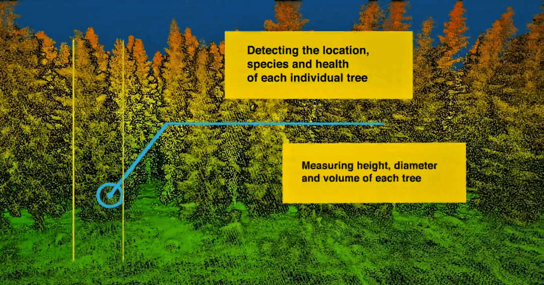
Overcoming the disparate challenges and obstacles that come in the way of forestry, drone technology has helped surpass the same through its varied applications. Thrusting the abstraction of aerial imagery and monitoring, drone applications have brought the specialization of topographic surveillance, aerial photography, thermal imagery, mapping , and more to the forefront of forest cultivation. The flexibility of drones allows them to capture high-resolution images and video in real-time, even during the humid tropical climate. Artificial Intelligence-powered drones, along with drones that use LiDAR (Light Detection and Ranging) can monitor and inspect large areas with focussed coverage that yields faster and precise results and data.
How Drones Help
 How Drones Help Forestry
Like a potent robot of convenience and sheer proficiency, drone technology caters to the wide operations of the forest ecosystem to help maintain the balance of biodiversity. Reinforcing the virtues of nature, drone application in forestry has widened the scope of improvement, and the prospect of advancements throughout.
- LIFE SAVING – Drones, as employed for search and rescue missions, draw in the advantages of immediate relief in threatening situations. As a means of wildlife monitoring and biodiversity checking, UAVs prove to be highly resourceful at random times of distress and danger, which are frequent occurrences in forest ecosystems. Operations and tasks of delivery of emergency medication, surveying for harmful activities, immediate aid to ailing lives, etc., are a few instances of applications of drones in forestry that save time and hence, life.
- HUMAN INTERACTION – Embodying the features of security and reliability, Unmanned Aerial Vehicles use their abilities to the limits to scan and cover the dense forest areas for potential harm or threats. Forest managers and officials may find it handy and skilful to adopt these winged aerial vehicles with their dependable qualities to survey and map regions with improved accuracy. This advances the level of efficiency of surveying and inspection and also recovers a fair amount of time, effort, and workforce.
- WILDLIFE MONITORING – Regrettable to mention, but one of the greatest dangers of forests are the liabilities and perils to wildlife and biodiversity. Embracing its association with flora and fauna, forests have to be monitored to ensure the protection of the same. With the help of drones and UAVs, the balance of the ecosystem can be maintained, to better degrees. Aerial imagery, mapping, and data processing as performed by the AI-powered drones express endangerment alerts, scan for potential threats to wildlife, and so on. Time-critical results help to validate data and provide relief and medication in worsened conditions.
- FOREST FIRE –

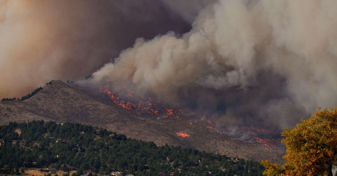
FOREST FIRE MONITORING Although completely eradicating the occurrences of forest fires are next to impossible, we sure can avoid it by miles. Menacing as they are, forest fires owe their devastating nature to more than one cause. By their speed and precision, drones can be used to scan the areas spanning the forests for potential threats of fires. The prior precautions lead to the prevention or immediate aid of the fires. Accounting for a major part of the forest ecosystem, animals, insects, and birds are also endangered by the harm that forest fires cause. Under their influences, UAVs aim to relieve these dangers and perils through their LiDAR sensors.
- TREE DISEASE DETECTION AND PREVENTION –
 TREE DISEASE DETECTION
Artificial Intelligence and Machine Learning fueling the drones have proved beneficial in the space of tree disease detection and prevention. LiDAR sensors in drones help accumulate and process data attributed to the wellbeing of trees, vegetation, and bushlands. Thermal imagery, topographic surveying, aerial mapping help locate diseased flora and navigate horticulturists and forest officials towards improving their conditions.
The Future of Forestry
Redefining the elements of forestry, drone technology entails merits towards the progress and advancement of the forest ecosystems. Drones, in this realm, push the boundaries of forest cultivation and maintenance, redeeming wildlife and vegetation, while also monitoring risks to prevent the felling of trees. With the adoption of drones, forestry can witness a high cascade of improvement and growth, like never before!


Excellent ideas throughout this post, personally I’m gonna have to bookmark this and come back to it. I’m curious if you have any follow ups to this post?