
Introduction
In its purest sense, road construction refers to the science and engineering of laying of the materials that give us safe and steady roads, bridges, and highways. However, road construction is not a one-time process but a periodic trail of road maintenance and sustenance operative measures. Civil engineers reinforce the revitalization and amelioration of roads through specific actions and approaches that lead to increased production and maintenance costs, exceeding the stipulated time of road development, unwanted delay of work resources and workforce, and significantly more
 Road Construction and Monitoring Using Drones
 Road Construction and Monitoring Using Drones
A reliable alternative for the desperate process of road construction and maintenance comes from Unmanned Aerial Vehicles (UAVs). With its advantages of smooth maneuverability, speedy and time-critical results, precise measurements, thorough and detailed surveying, drones or UAVs prove a suitable and resourceful substitute to conventional procedures. The onset of technology, as a whole, has entailed a plethora of possibilities and innovation that was otherwise confined inside the walls of our imagination. Drone technology, with its specialized features, has helped retrieve the construction industry, for good measure
How Is Drone Data Used in the Construction Industry

Technology, being at the forefront of innovation and advancements, has gravitated the need and application of drones to simplify the complexities associated with each industry. Similarly driving the construction industry, drone technology uses creative approaches to uplift this sector to higher peaks. The adoption of drones has resulted in drastic progress in the road construction sector, with a growth rate of 239%. This shows the immense utility drones have in this sector while augmenting the development of the applied industries.
With multiple advantages in this sector, drones provide a quick road survey, precise mapping, time-sensitive land surveys, and many more road management activities. These and relevant operations see the light of day under the excellent quality and accuracy of drone data. The visual data, content, and measurements collected from aerial surveying, mapping, and data processing are fuelled under the influence of LiDAR (Light Detection and Ranging) sensors and Artificial Intelligence automation and technology. Aerial mapping and surveying aids in recording this data that UAVs would process in a later stage to yield precisely correct measurements and information. The most significant merit of drone data collection and processing is its speed of aerial survey and mapping that ultimately accounts for bridge inspection and road construction. The nature of drone survey and imagery is fundamentally to produce time-critical yet accurate measurements that save time and entails efficiency and thus advancements of the construction industry.
Benefits of Using Drones for Road Mapping
An advanced yet perfect symbol of efficiency and performance, Unmanned Aerial Vehicles (UAVs) are the key to sustainable and effective road construction, highway infrastructure management, bridge inspection, and road management operations. Powered by new-age technologies, drones help in various situations, especially important for distress monitoring and many similar applications.
On-Demand Image Acquisition
Drone imagery pools in substantial benefits that amount to acquiring qualitative visual content and aerial photography. The use of orthomosaic maps for survey and mapping proves essential for timely and high-resolution aerial footage. The prospect of virtual tours and drone imagery lifts the stakeholders’ spirits even more so than on-foot land surveying. As received by drones, the sharpness and perceptiveness are unparalleled in terms of on-demand aerial imagery, drone data, and footage.
Accurate and Comprehensive Data
Example of Corridor Mapping
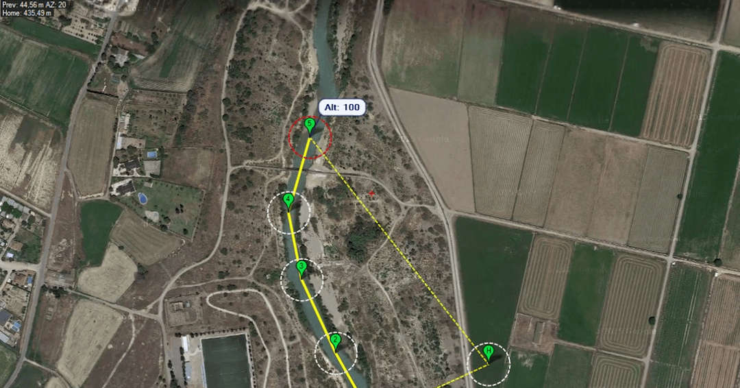 Example of Corridor Mapping
Drone technology, along with its robust features, has easy access to aerial imagery and footage. This encompasses the abilities of drones to deliver quick yet reliable data collected from land and road surveys. Pushing the limits of technology in the construction industry’s space brings in the advantages of acquiring, processing, and validating data to extract the useful information by 3D road mapping that leads to further determinations in this field. Drones and UAVs are primitively speedy and fast in retrieving the critical and factual information acquired by drone surveying.
Cost and Time-Saving
The most significant challenges of the construction industry, and most road construction, are time and production cost. Vital as they are, 80% of the buildings fail to complete their projects by the stipulated time, leading to an increment in the price. The delay in work is often attributed to unexpected, incidental occurrences, but mostly to the insufficiency and lack of resources like manpower, equipment and gear, machinery, instruction of use, and many others. The inability to complete the given construction in the expected time only induces an increase in production cost. Drones may conveniently eliminate this with their speedy data collection, quick mapping, and time-sensitive results. Their swift movement allows for easy maneuverability that gives immediate results and saves time and cost.
Maintenance and Asset Inspection
Road management and maintenance can be a burdensome process because it encompasses many elements of ensuring the health and wellbeing of the roads, highways, and bridges. Complete construction does not certify the welfare of the highways and falls on the shoulders of maintenance. Drones adopted for these purposes shed light on the challenges of care and aspire to relieve the roads of these said shortcomings. The smoothness and deftness of drones help to easily capture and identify the areas that require repair and provide the same. Asset inspection has seen a new approach with drones’ employment to survey in detail for any faults
Post Project Documentation
Drones have proved to be heavily instrumental in copious operations concerning road construction, highway infrastructure, and bridge inspection. Each project goes around bountiful documentation and reports that help bring the construction models to life. The drones’ application helps uncover the details that lie within every construction in terms of aerial footage and content. Drones help to easily detect these elementary details from their bird’s view of the roads and bridges. The data collected from drones by their specialized data processing abilities are used in the documentation records for further determinations. This saves time in terms of road mapping and surveying as performed by drones.
Highway Infrastructure Management
The role of drones in road maintenance and highway infrastructure management is relatively significant as they entail the construction industry’s essential aspects. Aerial footage seems to have an edge in these respects that helps to deliver substantial results.
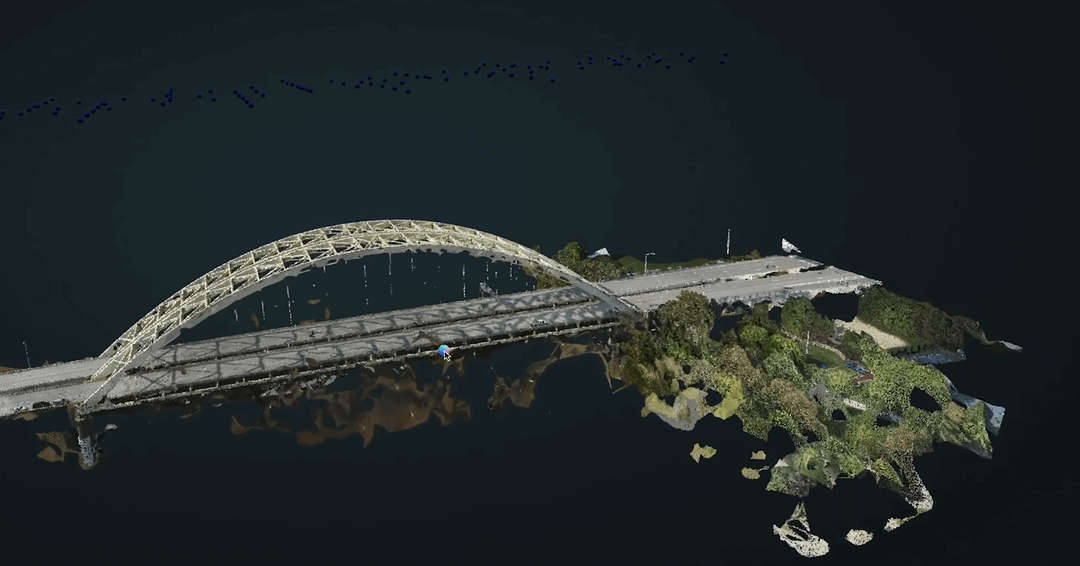
Bridge Inspection
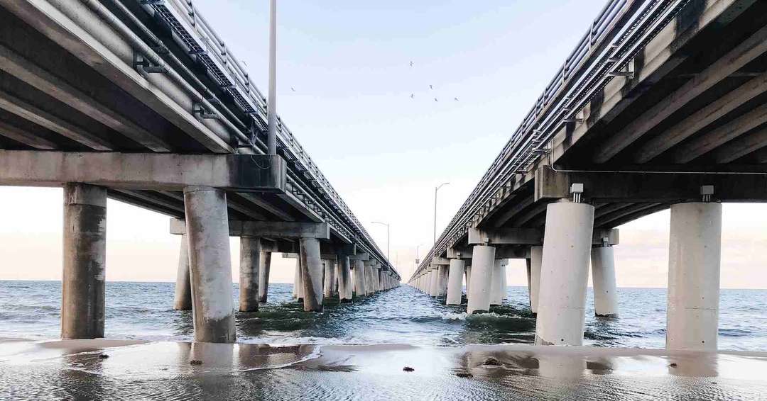
Drone technology, with its advancements, testifies as an excellent means of survey and mapping, amongst many others. The dynamic nature of these winged vehicles enables bridge inspection from all angles. The adoption of drones has helped conquer the inspection and surveying of remote locations by their small-size and swift maneuverability. The high-resolution cameras and sensors instilled in drones help acquire detailed and focused images and videos from all angles and shots
Pavement Conditions and Road Distress Monitoring
Road distress is often the sum of bountiful foul incidents, speeding vehicles, heavy vehicles, accidents, etc. These unpleasant events induce the desperate need for road distress monitoring. Unmanned Aerial Vehicles (UAVs) smoothen the tiring process of road reviewing and repair. By the operations of monitoring, surveying, and mapping, drones collect useful data for mapping. Furthermore, this records the areas and details that have been subject to damage. On identification, drones also perform tasks of delivering small tools and gear for repair. In this way, the worsened pavement conditions may be continually monitored, checked on, and repaired.
Corridor Mapping

The widespread popularity of drones is mostly due to drones’ feature that enables aerial footage and imagery. This allows stretches of land and roads to be covered in just a single shot. Proves to be effective with perceptions of workers’ safety and access to remote locations that otherwise may not be considered by workers. Drone technology is exceptionally resourceful to deliver these facets of road construction that add value to road construction and management’s abstraction.
Deliverables for Road Mapping
Orthomosaic
The content as captured by drones is skillful in image processing requirements such as image restoration, highlighting, and mapping. Drone imagery is used for creating visual orthomosaic maps that portray accuracy and detail. For a better quality of construction, tracking of road construction, timely work progress, and more may be traced that are made available to us in the form of these maps
3D Models
Drone technology is utilized to map the aerial footage captured in real-time for views to accentuate the construction model’s perception and its purpose. The 3D model helps create 3D references, prototypes, and similar notes for an enriched road construction and maintenance solution.
DSM And DTM

As performed by drones, photogrammetry produces essential resources and materials for construction management in the form of Digital Surface Models (DSM) and Digital Terrain Models (DTM). These help to zoom in on the small details that play a significant role in developing and constructing roads, bridges, and highways.